


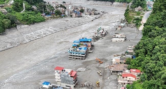
A massive glacier collapse in Nepal’s mountains near the Tibet border may have triggered a devastating chain of events that sent torrents of water, mud and debris through communities, killing at least 180 people.
Experts are still investigating the exact sequence of events, but satellite images, seismic data and water-monitoring records are helping scientists piece together what happened.
Glacier Collapse
Experts believe a huge section of glacier broke away from the mountains at an elevation of about 5,200 metres and plunged into a valley below.
Simon Cox, a principal scientist at New Zealand’s GNS Science, said the falling ice transformed into a powerful mass of water, rocks, trees and sediment as it moved downhill.
The debris swept through the valley, engulfing a border post before continuing downstream into Nepal, where villages were flooded and bridges and buildings were destroyed.
A Seismic Event, Not An Earthquake
The collapse was powerful enough to be detected as a seismic event and was initially mistaken for an earthquake.
However, analysis by the US Geological Survey later indicated that the event was caused by a glacier collapse and debris flow rather than an earthquake.
The event registered at magnitude 5.2 and occurred at about 8:37 am local time.
Scientists are still working to determine the amount of ice that collapsed. Cox estimated that the volume could have ranged from about 500,000 cubic metres to tens of millions of cubic metres.
Scientists Reconstruct The Disaster
With some of the affected areas difficult to access, researchers are relying heavily on satellite imagery and information from monitoring stations.
Lauren Vargo, a glaciologist at Victoria University of Wellington, said scientists could compare satellite images taken before and after the disaster to identify changes in the mountain and determine what material may have fallen.
A nearby water-monitoring station stopped transmitting shortly after the seismic event, while other stations downstream also went offline.
Nepali authorities said water levels reached as high as 12.3 metres at Kalikhola near the Tibet border.
Was A Glacial Lake Involved?
One possibility initially considered was a glacial lake outburst flood, or GLOF.
A GLOF occurs when a natural barrier holding back water from a glacial lake collapses, suddenly releasing a huge volume of water downstream.
However, some experts said there was no evidence of a large glacial lake near the collapse site.
Another theory is that water accumulated beneath the glacier and was released when the ice collapsed. The falling glacier could also have temporarily blocked the river, causing water to build up before the obstruction gave way.
Summer glacier melt and monsoon rainfall may have further increased river levels before the disaster.
Why The Flood Was So Destructive
As the initial surge travelled downstream, it picked up enormous quantities of mud, rocks, trees and other debris.
The resulting mixture became extremely destructive and difficult to escape.
Hydrologist Hatim Sharif of the University of Texas San Antonio warned that attempting to flee by car or simply running may not be enough when fast-moving water and debris are approaching.
For communities located below glaciers or glacial lakes, moving to significantly higher ground can provide the best chance of survival.
Climate Change Adds To The Risk
Scientists caution that it is too early to directly attribute this particular glacier collapse to climate change.
However, rising global temperatures are causing glaciers around the world to retreat, increasing risks associated with unstable ice, melting water and glacial lakes.
Glaciers also serve as important sources of water for communities downstream, meaning their continued retreat poses both immediate disaster risks and longer-term challenges for water supplies.
Experts say reducing greenhouse gas emissions and limiting global warming remains one of the most important ways to reduce the growing risks associated with a warming mountain environment.